Plitvice Lakes History & Geology Guide: How Croatia's Iconic Landscape Was Formed
Plitvice Lakes National Park isn't just a collection of pretty waterfalls and turquoise pools. It's a living geological laboratory — a landscape actively building itself through a process that has been running for roughly 10,000 years and continues at a measurable pace today. The travertine barriers that separate the park's 16 interconnected lakes grow by approximately one centimetre per year, which means the Plitvice you photograph on your visit will look slightly different from the Plitvice your grandchildren will see.
Understanding how Plitvice formed transforms a beautiful day trip into something genuinely awe-inspiring. When you know that every cascade, every moss-covered barrier, and every impossibly blue pool is the result of a specific chemical and biological process — one that requires a precise balance of water chemistry, temperature, vegetation, and microorganisms — the park shifts from scenic backdrop to living story.
This guide covers everything: the geological forces that carved and built Plitvice, the human history layered on top of it, its UNESCO World Heritage significance, the scientific research protecting it, and the challenges the park faces as climate and tourism pressure mount in the 21st century.
Geological History: How the Plitvice Lakes Formed
The Karst Foundation
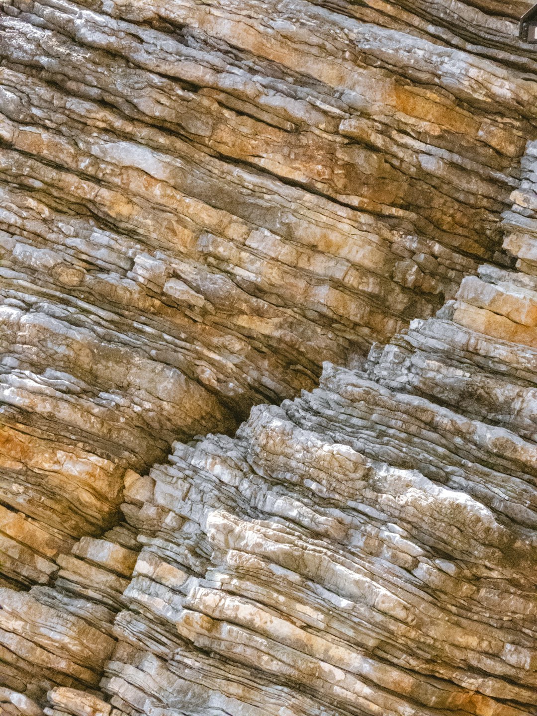
Plitvice Lakes exists because of karst — a type of landscape formed when soluble bedrock (in this case, limestone and dolomite) is gradually dissolved by slightly acidic water over millions of years. The bedrock underlying Plitvice was deposited during the Mesozoic Era, roughly 200 to 65 million years ago, when this part of Croatia lay beneath a warm, shallow sea. Over millions of years, the shells and skeletons of marine organisms accumulated on the seabed, compacting into thick layers of calcium carbonate rock.
As tectonic activity lifted these ancient seabeds above the waterline, rainfall began its slow, patient work. Rainwater absorbs carbon dioxide from the atmosphere and from soil as it percolates downward, forming a weak carbonic acid. This acid dissolves calcium carbonate, carving out underground channels, sinkholes, caves, and eventually the broad valleys that define the Plitvice landscape today. The Korana River and its tributaries — the Crna Rijeka (Black River) and Bijela Rijeka (White River) — flow through this porous, sculpted terrain, picking up dissolved calcium along the way.
This karst dissolution is why Plitvice's water is so remarkably clear. Unlike rivers flowing over clay or silt, the water here passes through limestone, which acts as a natural filter. Sediment settles in underground passages, and the water that emerges at the surface is exceptionally pure — loaded with dissolved minerals but virtually free of suspended particles.
The Travertine Barrier Creation Process
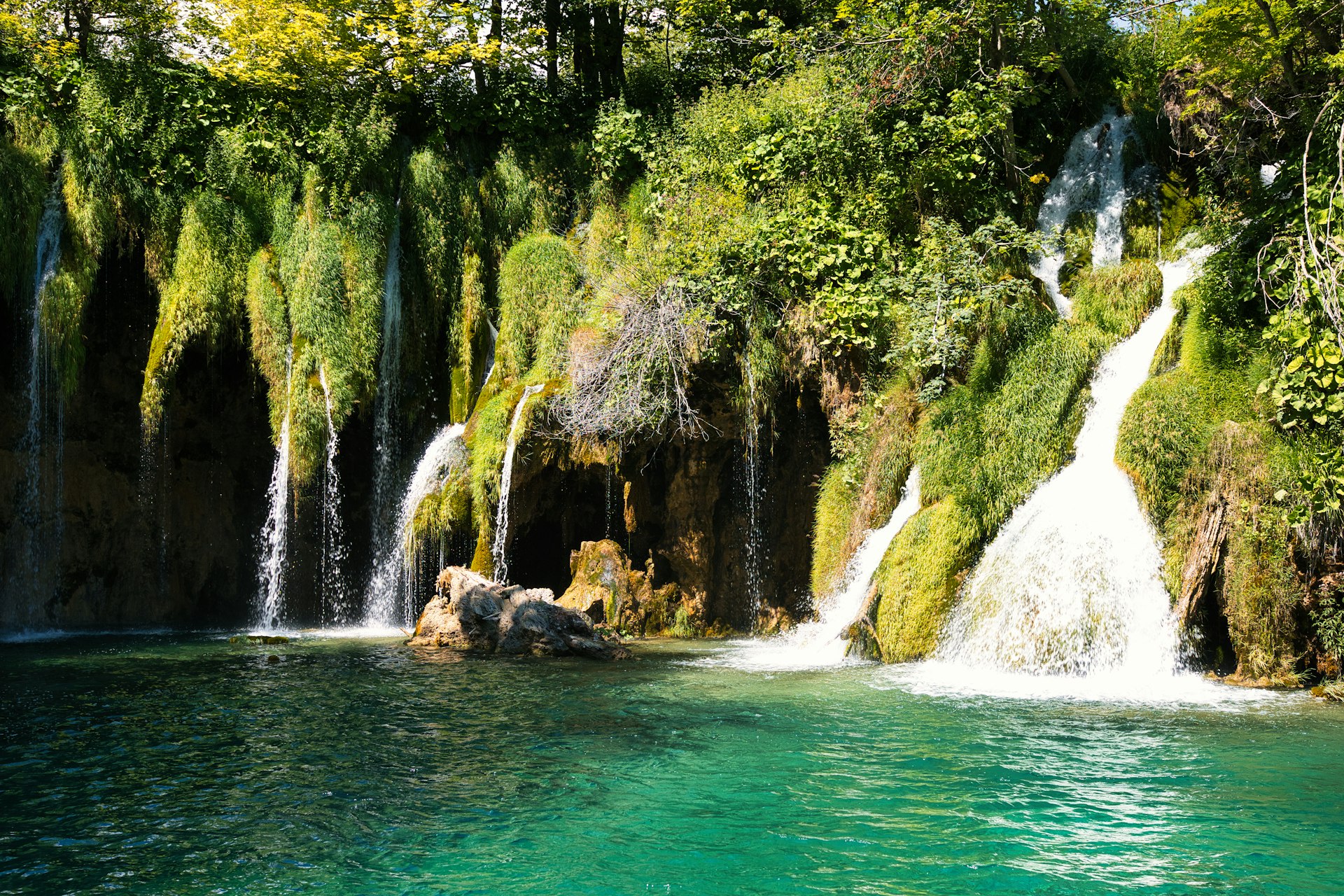
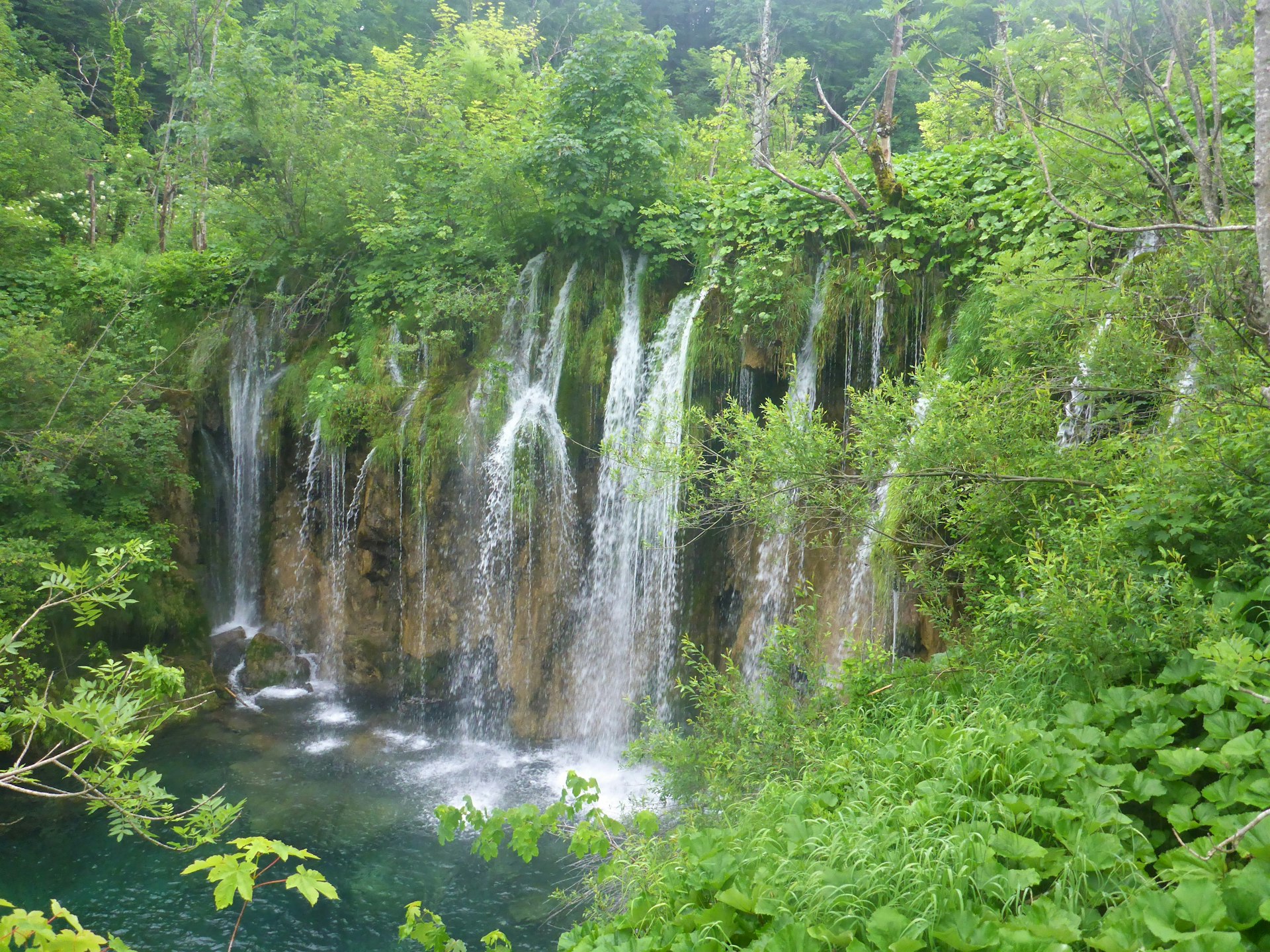
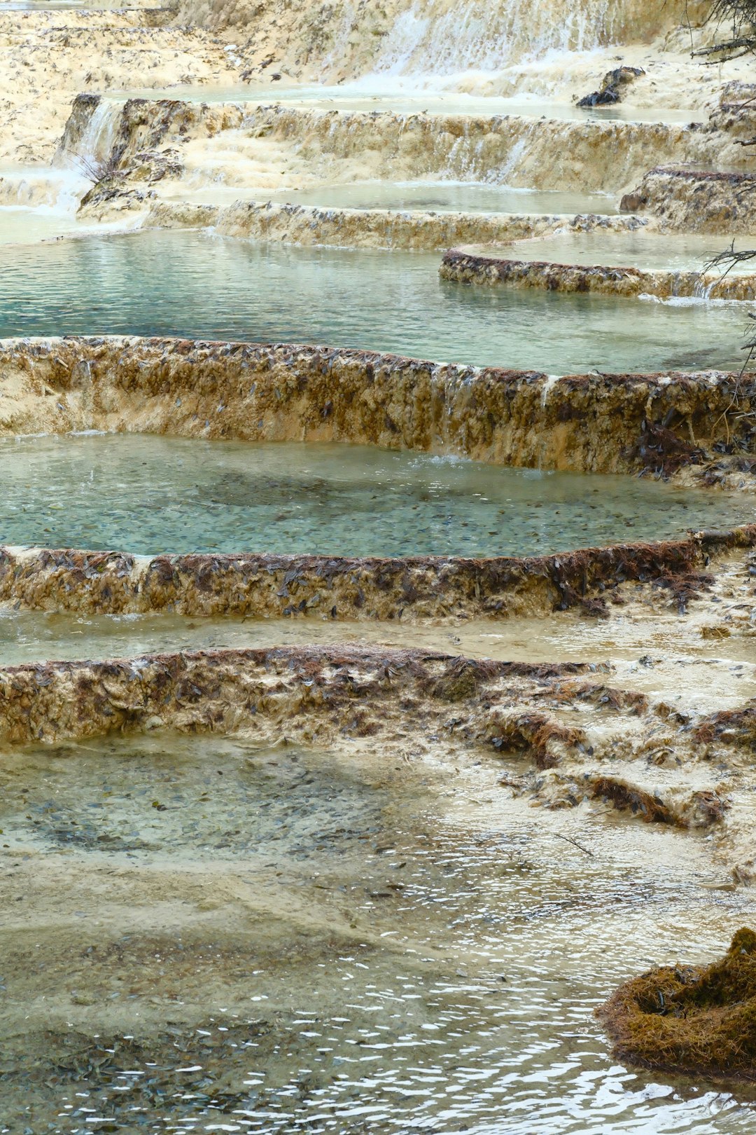
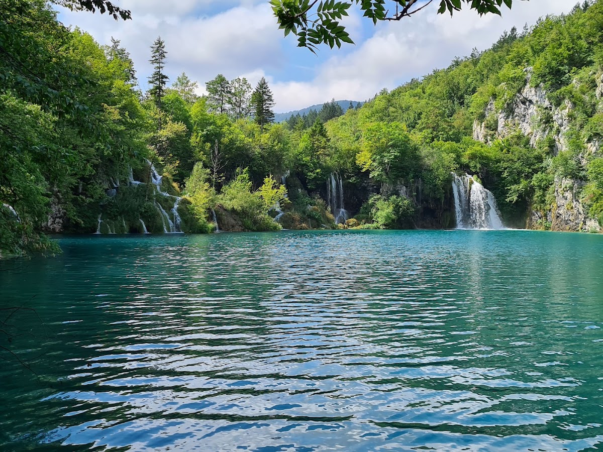
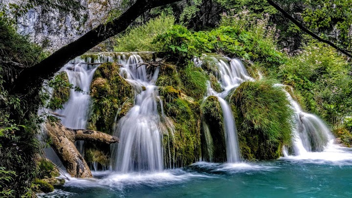
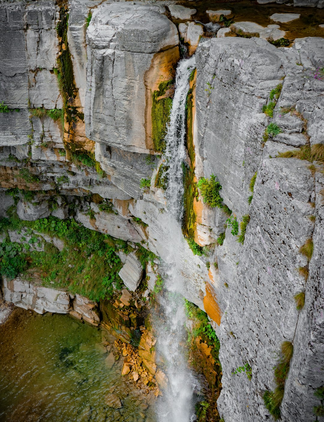
What makes Plitvice truly unique isn't the dissolution of rock — karst landscapes exist across the globe — but the reverse process: the precipitation of calcium carbonate out of solution, forming a rock called travertine (sometimes called tufa). This is the process that builds Plitvice's famous barriers, the natural dams that separate one lake from the next and create the waterfalls.
Here's how it works. Water flowing through Plitvice's karst terrain becomes supersaturated with dissolved calcium bicarbonate — Ca(HCO₃)₂. When this mineral-rich water reaches the surface and flows over obstacles — fallen logs, moss, algae, dead leaves — two things happen simultaneously:
Physical degassing: As water tumbles over barriers and cascades, it releases dissolved carbon dioxide into the atmosphere, much like opening a carbonated drink. This CO₂ loss shifts the chemical equilibrium, and calcium carbonate (CaCO₃) precipitates out of solution as a solid.
Biological mediation: This is the critical factor. Mosses, algae, cyanobacteria, and other microorganisms growing on submerged surfaces actively promote calcite deposition. Moss in particular plays a starring role — its intricate branching structure traps calcium carbonate particles, and the photosynthesis of algae and cyanobacteria living on the moss further reduces local CO₂ concentrations, accelerating precipitation. The result is that travertine doesn't just accumulate randomly; it builds up specifically on living moss, creating porous, sponge-like rock formations that gradually harden over time.
This biogenic process means Plitvice's travertine barriers are as much grown as they are deposited. The barriers are biological constructions, shaped by the organisms living on them. Remove the moss and microbes, and the process slows dramatically.
How the Lakes Formed
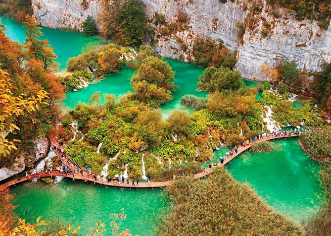
The 16 lakes of Plitvice are arranged in a cascading staircase pattern, descending roughly 130 metres over about 8 kilometres from the uppermost lake (Prošćansko Jezero, at 636 metres elevation) to the lowest (Novakovića Brod, at 503 metres). The lakes formed in sequence as travertine barriers accumulated across the existing river channels, damming the flow and creating pools that gradually filled with water.
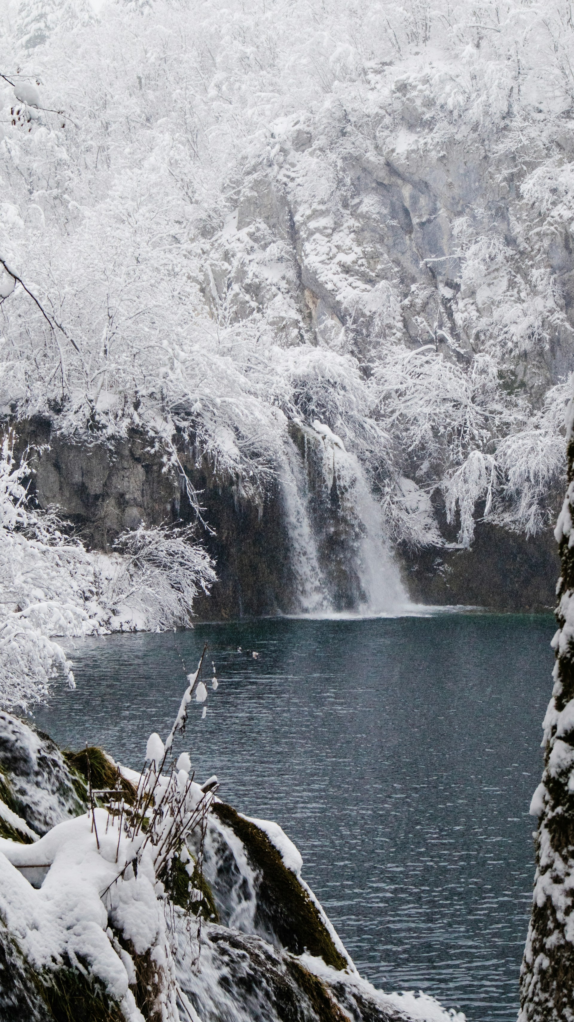
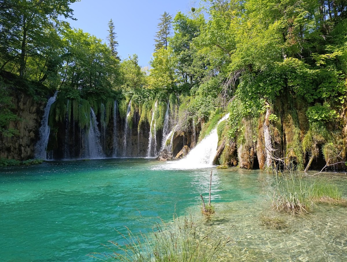
The upper lakes (Gornja Jezera) — Prošćansko Jezero, Ciginovac, Okrugljak, Batinovac, Veliko Jezero, Malo Jezero, Vir, and others — are generally larger, deeper, and surrounded by thick dolomite-rich forest. They sit in a broad valley carved by glacial and fluvial erosion. The lower lakes (Donja Jezera) — including Milanovac, Gavanovac, Kaluđerovac, and Novakovića Brod — are smaller, shallower, and set in a steep-walled limestone canyon. The transition between the two systems is marked by the park's most dramatic waterfalls, including Veliki Slap (the Great Waterfall), Croatia's tallest at 78 metres.
Each lake's depth, colour, and character depend on the height of its downstream travertine barrier, the mineral content of its water, the depth of sunlight penetration, and the algae and organisms living within it. The famous turquoise, emerald, and azure colours are produced by the interaction of sunlight with dissolved minerals and microscopic organisms — not by the water itself.
Why Plitvice Keeps Changing
Plitvice is not a static landscape. The travertine barriers grow continuously — roughly 1 to 1.3 centimetres per year under optimal conditions — which means the lakes are slowly but constantly reshaping themselves. A barrier that grows faster on one side can redirect water flow, creating new cascades while old ones dry up. Fallen trees that become encrusted in travertine form new dams. Existing barriers occasionally collapse under their own weight or from erosion, merging previously separate pools.
This dynamism is why the park looks different from decade to decade. Photographs from the 1960s show waterfall patterns that no longer exist, and new cascades have appeared where none stood before. Scientists estimate that the current barrier system at Novakovića Brod has raised the water level of the lower lakes by roughly 2 metres over the past century alone.
Geological Timeline
| Period | Event |
|---|---|
| 200–65 million years ago | Limestone and dolomite bedrock deposited in shallow Mesozoic seas |
| 65–2 million years ago | Tectonic uplift raises seabed above waterline; karst dissolution begins |
| ~2 million years ago | Pleistocene glaciation sculpts valleys and drainage patterns |
| ~10,000 years ago | Post-glacial travertine deposition begins; lake formation starts |
| ~8,000 years ago | Upper lakes reach approximately their current extent |
| ~4,000 years ago | Lower lakes begin forming in the steep canyon section |
| Present day | Barriers continue growing at ~1 cm/year; landscape actively evolving |
Human History at Plitvice
Ancient Settlements
The Plitvice region has been inhabited since at least the late Bronze Age, roughly 1000 BCE. Archaeological evidence — pottery fragments, tools, and traces of fortified settlements — indicates that Illyrian tribes, specifically the Iapydes (Japodi), lived in the surrounding hills and used the lakes and rivers as water sources and fishing grounds. These pre-Roman peoples built hilltop fortifications (gradine) throughout the Lika region, and several such sites have been identified within the modern park boundaries and in adjacent areas.
When the Romans conquered the region in the 1st century BCE, they incorporated the Lika-Krbava area into the province of Dalmatia. Roman roads crossed the region, connecting coastal settlements to the interior. While no major Roman settlement has been found at Plitvice itself, Roman-era artefacts discovered nearby suggest the area served as a transit zone and resource area rather than an urban centre.
Medieval Period and Ottoman Frontier
After the fall of the Western Roman Empire, the region came under the control of various medieval Croatian rulers. By the 7th century, Slavic Croats had settled throughout the area, establishing agricultural communities in the fertile valleys surrounding the lakes. The region became part of the medieval Croatian kingdom, and later fell under Hungarian-Croatian rule.
The Ottoman expansion into the Balkans in the 15th and 16th centuries transformed the Plitvice area into a military frontier zone — the Vojna Krajina (Military Frontier). The Habsburg Empire established fortified border settlements populated by Serb and Croat refugees fleeing Ottoman territory. This frontier character defined the region for centuries, and the mixed ethnic composition it produced would have devastating consequences in the 1990s. During this period, small farming and pastoral communities lived near the lakes, but the area remained sparsely populated and largely undeveloped.
Modern Discovery and Tourism Development
The first known written description of the Plitvice Lakes dates to 1777, when the Dominican priest Dominik Vukasović recorded the site. However, the lakes didn't enter wider European consciousness until the mid-19th century. In 1861, the first guesthouse was built near the lakes, and in 1893 the Društvo za uređenje i uljepšavanje Plitvičkih jezera (Society for the Arrangement and Beautification of Plitvice Lakes) was founded — one of the earliest conservation organisations in the region.
Plitvice was declared a national park on April 8, 1949, making it one of the first national parks in Southeast Europe. The Yugoslav government invested heavily in tourism infrastructure during the 1950s through 1980s, building hotels (including the still-operating Hotel Jezero), paved roads, the electric boat system on Kozjak Lake, and the iconic wooden boardwalks that now define the visitor experience. By the late 1980s, Plitvice was attracting over 700,000 visitors per year.
War Impact: The 1990s
On March 31, 1991 — Easter Sunday — the Plitvice Lakes became the site of the first armed clash of the Croatian War of Independence, known as the "Plitvice Bloody Easter" incident. Serbian paramilitary forces and Croatian police exchanged fire in and around the park, resulting in two deaths: one Croatian police officer and one Serbian insurgent. The incident is widely regarded as the first combat deaths of the Yugoslav Wars.
Serbian forces subsequently occupied the park and surrounding area from 1991 to 1995. During the occupation, tourism ceased entirely, infrastructure was damaged (though the natural formations themselves survived largely unscathed), and landmines were planted along trails and roads. The park was liberated during Operation Storm in August 1995. Demining operations continued for years afterward, and some peripheral areas of the broader Plitvice region were not fully cleared until the early 2000s.
The park reopened to visitors in 1998 and embarked on a recovery that has been remarkably successful. Visitor numbers surpassed pre-war levels by the mid-2000s, and by 2019, annual visitation had reached approximately 1.6 million — creating an entirely new set of challenges.
UNESCO World Heritage Status
The 1979 Designation
Plitvice Lakes National Park was inscribed on the UNESCO World Heritage List in 1979, becoming one of the first natural sites in the world to receive the designation. It was added under Natural Criteria (vii) and (viii):
- Criterion (vii): The park contains "superlative natural phenomena" and areas of "exceptional natural beauty and aesthetic importance." The cascading lakes, waterfalls, and surrounding forests constitute one of the most visually striking karst landscapes on Earth.
- Criterion (viii): The park is "an outstanding example representing significant ongoing geological processes." The active travertine deposition at Plitvice is one of the best-studied and most complete examples of this geological phenomenon anywhere in the world.
The 1979 inscription covered approximately 19,462 hectares. The site was extended in 2000 to include a buffer zone, bringing the total protected area to approximately 29,685 hectares.
Why Plitvice Was Chosen
Several factors made Plitvice an ideal early World Heritage site. The travertine barrier system is the primary geological reason — while travertine deposits exist elsewhere (notably at Pamukkale in Turkey and Huanglong in China), Plitvice's system is distinguished by its scale, its ongoing dynamism, and the biological processes driving it. The 16 interconnected, terraced lakes represent the most complete example of a travertine-dammed lake system in the world.
The park's biodiversity also contributed to the designation. Plitvice's forests include pristine stands of European beech, spruce, and fir that represent some of the best-preserved old-growth forest in southeast Europe. The park supports populations of brown bear, wolf, lynx, and more than 160 bird species — making it one of the most ecologically significant protected areas in the European continent.
Conservation Efforts and Protection Measures
UNESCO designation brought international obligations. Croatia (and before 1991, Yugoslavia) committed to maintaining the park's "Outstanding Universal Value" — the specific qualities that justified inscription. In practice, this has meant:
- Strict zoning: The park is divided into management zones with different levels of access. Core wilderness areas are off-limits to visitors; scientific research zones have restricted entry; the tourism zone covers the boardwalk trails, boat routes, and shuttle bus roads.
- Water quality monitoring: Continuous monitoring of water chemistry at multiple points throughout the park ensures that the travertine deposition process remains healthy. Any significant change in pH, calcium concentration, or dissolved CO₂ could signal a threat to barrier formation.
- Visitor management: In response to overcrowding concerns, the park introduced a daily visitor cap system. As of 2026, the park limits entry to approximately 10,000 visitors per day during peak season, with timed entry slots introduced to distribute visitor flow.
- Infrastructure control: No new hotels or large structures are permitted within the park core. Existing infrastructure (boardwalks, boat docks, shuttle roads) is maintained with materials and methods designed to minimise environmental impact.
During the 1991–1995 war, UNESCO placed Plitvice on the World Heritage in Danger list due to the military occupation and landmine contamination. It was removed from the danger list in 1997 following the park's liberation and the beginning of restoration efforts.
Scientific Research at Plitvice
Ongoing Studies
Plitvice has been a subject of scientific study since the late 19th century, but the pace and sophistication of research has accelerated dramatically in recent decades. The park maintains partnerships with Croatian universities (particularly the University of Zagreb), the Croatian Geological Survey, and international research institutions.
Current research programmes focus on several areas. Hydrogeology studies track water flow through the park's karst system, mapping underground connections between surface streams and measuring how water chemistry changes along the lake chain. Geochemistry research monitors the rate and composition of travertine deposition, which serves as both a record of past climate conditions and an indicator of current environmental health. Biological surveys catalogue the park's flora and fauna, with particular emphasis on organisms involved in the travertine process — the mosses, algae, and cyanobacteria that mediate calcium carbonate precipitation.
Remote sensing and drone surveys, introduced in the 2010s, now provide high-resolution topographic data that allows scientists to measure changes in barrier height and lake surface area with centimetre-level precision. This represents a significant advance over earlier methods, which relied on ground-level measurements taken at irregular intervals.
Endemic Species and Biodiversity Discoveries
Plitvice's relative isolation and ecological diversity have produced several endemic or near-endemic species — organisms found only here or in a very limited range. The park's cave systems harbour endemic cave-dwelling invertebrates, including species of amphipods and isopods adapted to permanent darkness. The park's old-growth forests support populations of rare fungi and lichens that require undisturbed ancient woodland.
Among the park's more charismatic species, the European brown bear population is perhaps the most significant. Plitvice and the surrounding Lika region form part of a critical bear corridor connecting bear populations across the Dinaric Alps. The park's wolf population, while small and elusive, represents one of the westernmost established wolf packs in Europe. Eurasian lynx have also been confirmed in the park, completing the triumvirate of European large carnivores. Over 160 bird species have been recorded, including several woodpecker species that depend on old-growth forest habitat.
Climate Change Impacts
Climate change poses a direct threat to the processes that sustain Plitvice. Research has documented several concerning trends. Average water temperatures in the lakes have risen measurably over the past three decades. Precipitation patterns are shifting, with drier summers and more intense autumn-winter rainfall events replacing the historically more even distribution. Snowpack in the surrounding mountains — a crucial source of spring and early summer water flow — has declined.
These changes matter because the travertine deposition process is sensitive to water temperature, flow rate, and chemistry. Higher water temperatures can alter the composition of moss and algae communities, potentially reducing the biological mediation that drives calcite precipitation. Reduced summer flow means less water passing over the barriers, slowing deposition. More intense rainfall events can cause erosion that damages existing barriers faster than new travertine can replace them.
Water Quality Monitoring
Water quality monitoring at Plitvice is among the most comprehensive of any protected area in Europe. Automated stations at multiple points along the lake chain continuously measure temperature, pH, dissolved oxygen, conductivity, turbidity, and calcium carbonate saturation. Additional manual sampling covers nutrients (nitrogen, phosphorus), heavy metals, and microbiological parameters.
This monitoring programme serves a dual purpose. It protects the park's ecological health by detecting pollution or environmental changes early — any upstream agricultural runoff, sewage contamination, or chemical change triggers investigation and response. It also provides a long-term scientific dataset that researchers use to study how travertine systems respond to environmental change over decades and centuries.
Cultural Significance
Croatian National Identity
Plitvice Lakes occupies a unique place in Croatian national consciousness. It was one of the first sites identified for protection in the country's history, predating Croatian independence by decades. The park's image appears on Croatian currency, postage stamps, and tourism materials — it is, alongside Dubrovnik, the single most recognisable Croatian landmark internationally.
The park's significance deepened after the Croatian War of Independence. The "Bloody Easter" incident of 1991 made Plitvice a symbol of Croatian sovereignty and the human cost of defending it. The first police officer killed in the conflict, Josip Jović, is commemorated annually at the park, and a memorial near Entrance 1 marks the event. For many Croatians, Plitvice represents not just natural beauty but national identity — a place worth protecting and fighting for.
Legends and Folklore
Local folklore attributes the creation of the Plitvice Lakes to a legendary figure known as the Crna Kraljica — the Black Queen. According to the most common version of the legend, the region suffered a terrible drought, and the people prayed desperately for rain. The Black Queen answered their pleas by summoning a great storm that filled the valleys with water, creating the lakes. Some versions of the story connect the Black Queen to the name of the Crna Rijeka (Black River), one of the two main tributaries feeding the lake system.
Other local traditions associate the lakes with fairies (vile) — supernatural beings common in South Slavic folklore — who were said to dance on the lake surfaces at night and guard the waters from those who would harm them. These folk traditions reflect the deep connection between the local population and the natural landscape, a relationship stretching back centuries.
Origin of the Name
The exact origin of the name "Plitvice" is debated. The most widely accepted etymology derives from the Old Slavic word plit or plitva, meaning "shallow" — a reference to the shallow, wide lakes that characterise parts of the system. Another theory links the name to the Croatian word pličina (shallow water or shoal). Some local scholars have proposed connections to earlier pre-Slavic roots, but definitive etymological evidence is scarce.
The first recorded use of the name "Plitvice" in its modern form dates to a 1777 document, though the lakes were certainly known by name to local populations long before that.
Future Challenges
Climate Change
The most significant long-term threat to Plitvice is climate change. As outlined in the scientific research section, rising temperatures, shifting precipitation patterns, and declining snowpack directly threaten the travertine deposition processes that created and sustain the lakes. If deposition slows or stops, the barriers will erode faster than they grow — gradually degrading the very features that make Plitvice unique. Scientists are modelling various climate scenarios to predict how the park will respond over the coming decades, but uncertainty remains high.
Tourism Pressure
Visitor numbers reached 1.6 million per year before the COVID-19 pandemic, and post-pandemic recovery has pushed numbers even higher. While the daily cap system helps manage peak-day crowding, the cumulative impact of millions of feet on boardwalks, boats on the lakes, and buses on the roads generates wear on infrastructure and ecological stress. Balancing the economic benefits of tourism (Plitvice is a critical revenue source for the Lika region) against the conservation imperative to limit human impact is an ongoing policy challenge.
Conservation Balance
The fundamental challenge is maintaining the delicate conditions that allow travertine deposition to continue. This requires clean water, stable flow, appropriate temperature, and thriving biological communities on the barriers. Upstream land use, regional development, and global climate trends all threaten these conditions. Croatia's national park authority, in partnership with UNESCO and international scientific organisations, continues to develop management strategies aimed at preserving the geological processes that make Plitvice a living, growing, and irreplaceable landscape.
Frequently Asked Questions
How old are the Plitvice Lakes?
The current lake system began forming approximately 10,000 years ago, at the end of the last Ice Age, when post-glacial warming created conditions favourable for travertine deposition. However, the underlying limestone bedrock is far older — deposited 200 to 65 million years ago during the Mesozoic Era. The karst landscape itself has been evolving for millions of years.
How were the Plitvice Lakes formed?
The lakes formed through a process called travertine (tufa) deposition. Water flowing through the park's limestone karst becomes supersaturated with dissolved calcium carbonate. When this water flows over mosses, algae, and other vegetation, the calcium carbonate precipitates out and gradually builds natural dams (travertine barriers). Over thousands of years, these barriers accumulated and dammed the rivers, creating the 16 terraced lakes you see today.
Are the Plitvice Lakes still growing?
Yes. The travertine barriers grow by approximately 1 to 1.3 centimetres per year under optimal conditions. This means the lakes are continuously changing — new cascades form, existing waterfalls shift, and lake levels gradually adjust. The park you see today will look measurably different in a few decades.
Why is the water at Plitvice Lakes so blue?
The vivid turquoise, emerald, and azure colours are produced by the interaction of sunlight with dissolved calcium carbonate minerals and microscopic organisms in the water. The extremely high water clarity (due to natural limestone filtration) allows sunlight to penetrate deep into the lakes, where it is selectively absorbed and reflected depending on water depth, mineral concentration, and the biological activity of algae. The colour varies with season, weather, and viewing angle.
When did Plitvice become a UNESCO World Heritage Site?
Plitvice Lakes was inscribed on the UNESCO World Heritage List in 1979, making it one of the first natural sites to receive this designation. It was recognised for its outstanding natural beauty (Criterion vii) and as an exceptional example of ongoing geological processes (Criterion viii). During the Croatian War of Independence, it was placed on the World Heritage in Danger list from 1992 to 1997.
What happened at Plitvice during the Croatian War?
On March 31, 1991 (Easter Sunday), the first armed clash of the Croatian War of Independence occurred at Plitvice Lakes — an event known as "Bloody Easter." Serbian paramilitary forces and Croatian police exchanged fire, resulting in two deaths. The park was subsequently occupied by Serbian forces until Croatia's Operation Storm in August 1995. During the occupation, the park was closed to tourism and landmines were planted in the area. The park reopened in 1998 and was fully restored to normal operations within a few years.